Airborne hyperspectral water body image stitching and content inversion
Introduction
Water is the source of life, and as the blood of the ecosystem, it is the basis of human survival, production and life, and sufficient and high-quality water resources are the primary condition for the healthy cycle of the ecosystem. However, water resources are very vulnerable to pollution, especially some inland water bodies, due to the natural confinement of its pollution problem is more prominent, while water resources as a carrier of pollutants, with dynamic diffusion and spread characteristics, will further aggravate the degree of pollution of water bodies. There are many oceans and lakes in China, along with the rapid development of the economy and the enhancement of human activities, the problem of water quality pollution in oceans and lakes has become increasingly serious. It has become a key factor limiting the sustainable development of cities, so it is necessary to use high-tech means to carry out research on water quality pollution in oceans and lakes, to provide timely and rapid water quality conditions in oceans and lakes, to protect people's normal production and life.
The development and progress of remote sensing technology have opened up new ways for monitoring and research of marine and lake water bodies. Remote sensing water quality monitoring technology with superior dynamic, low cost and macroscopic and other significant features, in the ocean, lake water quality pollution research has the advantages of conventional detection cannot be replaced. It can meet the needs of large-scale water quality monitoring, reflect the distribution and changes in water quality in space and time, to make up for the shortcomings of a single use of water sampling, but also to find some conventional methods difficult to reveal the distribution of pollution sources and the migration characteristics of pollutants and the scope of impact, to provide the basis for the scientific deployment of water sampling points. Hyperspectral remote sensing is widely used in remote sensing water quality monitoring due to its high accuracy, multi-band, enormous amount of information and other characteristics, which greatly improves the accuracy of water quality parameters estimation. Along with the continuous progress of remote sensing technology, water quality monitoring has shifted from qualitative description to quantitative analysis, while the water quality parameters that can be monitored have gradually increased and the accuracy of inversion has been improved, playing a significant role in the protection, planning and sustainable development of water resources.
1 Materials and experimental parts
1.1 Study area selection
A total of two field test flights were conducted on a section of the sea surface in a city in China. In the experiment, the DJI six-rotor UAV M600 Pro (net weight of UAV is about 4 kg, and the maximum load is about 10 kg) is used, and the GaiaSky-mini-2, a hypercritical imaging spectrometer developed by Jiangsu Dualix Spectral Imaging Technology Co., Ltd.. The main parameters are shown in Table 1. The flight altitude of the UAV was 300m, and 33 and 87 images were acquired respectively, and the conscious view of the UAV remote sensing platform is shown in Figure 1.
Table 1 GaiaSky-mini2 airborne imaging hyperspectrometer system parameters
|
No
|
Projects
|
Parameters
|
|
1
|
Spectral scan range/nm
|
400~1000
|
|
2
|
Spectral resolution/nm
|
3.5 nm
|
|
3
|
Imaging lens/mm
|
18.5
|
|
4
|
Number of spectral channels
|
360
|
|
5
|
Full frame pixels
|
1936×1456
|
|
6
|
Sensor
|
CCD Sony ICX 674
|
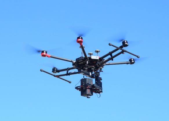
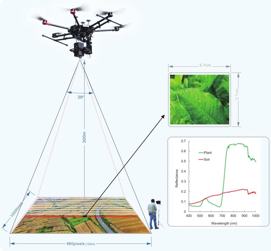
Figure 1 UAV hyperspectral imaging system in real life
The pre-processing of the UAV hypercritical images is carried out in the SpecView software developed by Jiangsu Dualix Spectral Imaging Technology Co., Ltd., including mirror transformation and black and white frame calibration (as shown in Equation 1).
 (1)
(1)
In equation (1), Rref is the reflectance value of the black and white corrected image, DNraw is the DN value of the original image, DNwhite is the white frame data of the whiteboard, and DNdark is the systematic error DN value of the camera.
Considering that the hypercritical image data acquired by the hypercritical imager may be affected by the atmosphere, water vapor and other factors after the UAV flies to a certain altitude. In order to eliminate the influence of these factors, we place a 2m*2m gray cloth calibrated by the National Institute of Metrology in the shooting area before the UAV takes off, and only need to cover to the gray cloth in one of the hypercritical images when the hypersensitive images are acquired. The method to eliminate the influence of atmospheric and water vapor factors is presented in Equation 2.
 (2)
(2)
In equation (2), Rfixed is the spectral reflectance of the image after eliminating atmospheric and water vapor factors, Rref is the reflectance of the image after black and white correction, Rstandard is the spectral reflectance of the gray cloth calibrated by the Chinese National Institute of Metrology, and Rgrayref is the spectral reflectance of the gray cloth in the image after black and white correction.
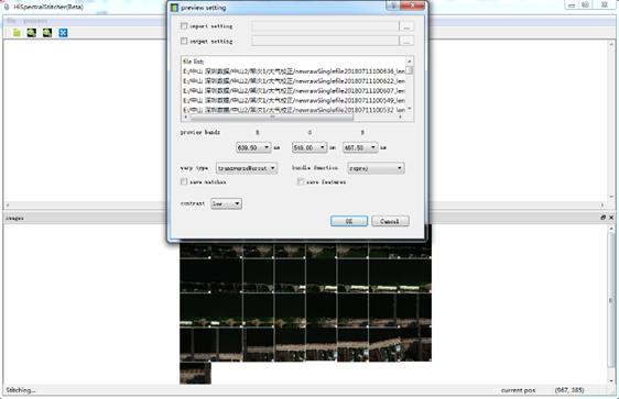
1.2 UAV hyperspectral image stitching
The stitching of UAV hypercritical images is performed by SpecStitcher, a UAV hypercritical stitching software developed by Jiangsu Dualix Spectral Imaging Technology Co., Ltd. . The interface of the splicing software is shown in Figure 2.
|
|
|
Figure 2 UAV hyperspectral stitching software SpecStitcher
|
2 Results and Analysis
2.1 Preview of stitching results
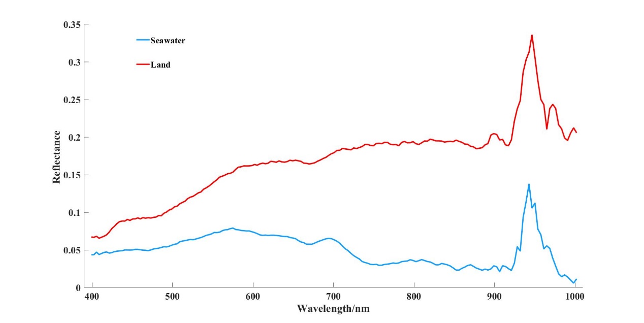
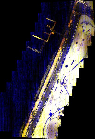
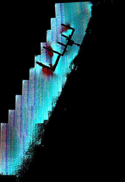
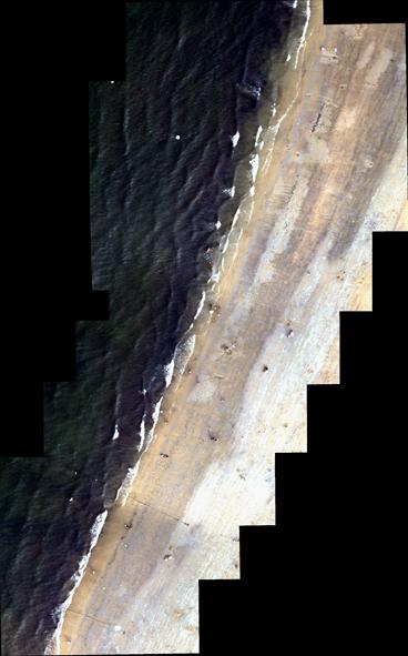
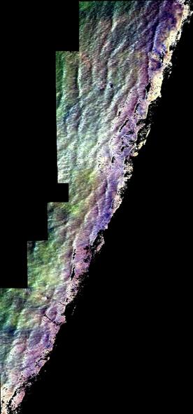
The extracted spectral curves of land and seawater are shown in Figure 3. Figure 4 (left) and Figure 5 (left) show the preview of the three-band stitching results of the UAV hypercritical images of the sea surface and its coast using the UAV hypercritical stitching software SpecStitcher (RGB represents the nearest wavelength of 640 nm/550 nm/460 nm, respectively). The stitching results show that the first and second acquired sea surface image data are better stitched together.
|
|
|
Figure 3 Comparison of spectral curves
|
|
|
|
|
Figure 4 Preview of the first data UAV hyperspectral stitching (left) and seawater data extraction (right)
|
|
|
|
|
Figure 5 Preview of the second data UAV hyperspectral stitching (left) and seawater data extraction (right)
|
2.2 River extraction methods for UAV hyperspectral images
UAV hypercritical images contain not only rivers but also other trees, weeds, soil, roads, buildings, etc. The usual methods to extract the target objects of interest from the images are unsupervised classification, supervised classification, decision tree, object-oriented classification, etc. In this study, the stitched UAV hypercritical images are classified by the Marxist distance method of supervised classification, so that the information of seawater in the data twice is extracted. And the inversion of water quality parameters such as visible total oxygen, total phosphorus and permanganate was performed for the second seawater. Extracted seawater information from the two flight is shown in Figure 4 (right) and Figure 5 (right).
2.3 Inversion of total nitrogen, total phosphorus and permanganate
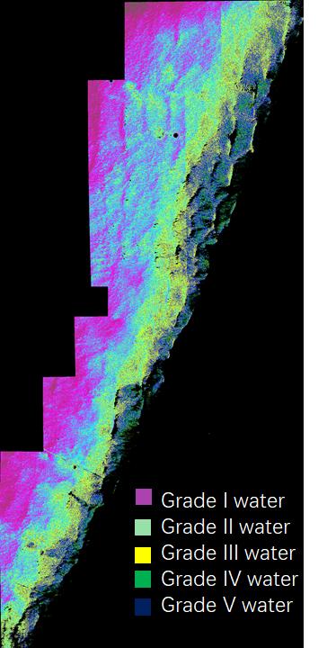
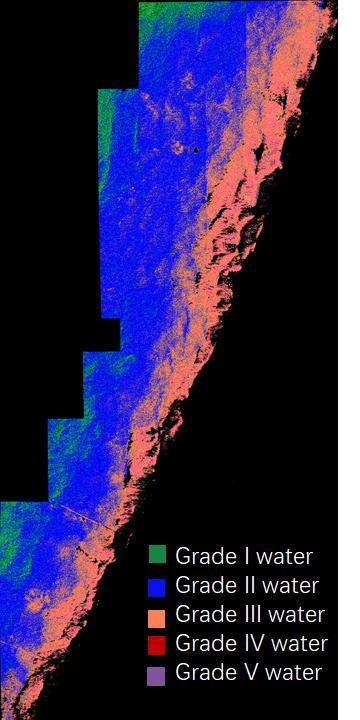
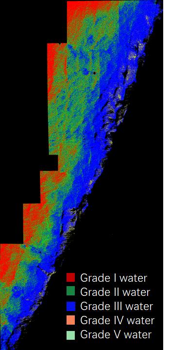
The content of total nitrogen, total phosphorus and permanganate in water bodies is a key indicator of water quality. The conventional methods of measuring nitrogen, phosphorus and permanganate require long time high temperature and high pressure ablation, and the temperature, time and reagents of the ablation have a great influence on the results, and the whole operation is tedious, time-consuming and labor-intensive. Therefore, this study attempts to explore the relationship between nitrogen, phosphorus and permanganate and the characteristics of reflection spectra in water bodies through the determination of nitrogen, phosphorus and permanganate spectra by using hypercritical remote sensing technology, establish the inverse model of nitrogen, phosphorus concentration and permanganate for lakes. The inverse model of nitrogen, phosphorus concentration and permanganate are used to provide a theoretical basis for remote sensing Quantitative monitoring of nitrogen, phosphorus and permanganate in large inland water bodies such as lakes, reservoirs and rivers. Some current studies only establish remote sensing information models of total nitrogen, total phosphorus and permanganate based on the close correlation between total nitrogen, total phosphorus and permanganate and seawater quality. Taking the second UAV flight data as an example, the distribution maps of total phosphorus concentration, total nitrogen and permanganate concentration of seawater were inferred using airborne hypercritical images, as showed in Figure 6.
|
|
|
|
|
(a) Total phosphorus
|
(b) Total nitrogen
|
(c) Permanganate
|
|
Figure 6 Content inversion diagram
|
3.Results and Discussion
In this paper, we take the seawater as the research object, use the UAV to carry the hypercritical imager to obtain the spectral image information of the sea surface, and then use the stitching software to stitch the acquired images to get the complete section of hypercritical image data of the sea surface. In this study, since the water quality information of the sea surface was not obtained, we can only look up the domestic and foreign journal literature to find out the relevant models of domestic and foreign scholars using hypercritical imager to study the eutrophication and water pollution degree of water bodies and lakes, and it can be seen through a large amount of literature review that most of the current studies on eutrophication or water pollution of rivers, lakes and oceans only stay at the ground or mega-scale satellite level, and few researchers have studied the eutrophication and water pollution of rivers and lakes in the field of ground and space. In this paper, based on the hypercritical data models compiled by the current researchers to study the eutrophication and water pollution in the ocean and lakes at ground level, we select the classical models with good stability to invert the eutrophication (total nitrogen, total phosphorus and permanganate) in two sections of sea surface. Based on the field research and the effect of hypercritical image inversion, the eutrophication and pollution degree of the sea surface can be reflected to a certain extent by using UAV hypercritical, and the distribution of eutrophication and pollution of seawater on the image can be used to determine the source of pollution and the cause of eutrophication of the water body. The results of the study can provide technical support for water resources management by water conservancy and hydropower departments and environmental protection departments.

 13910278534
 010-56370168